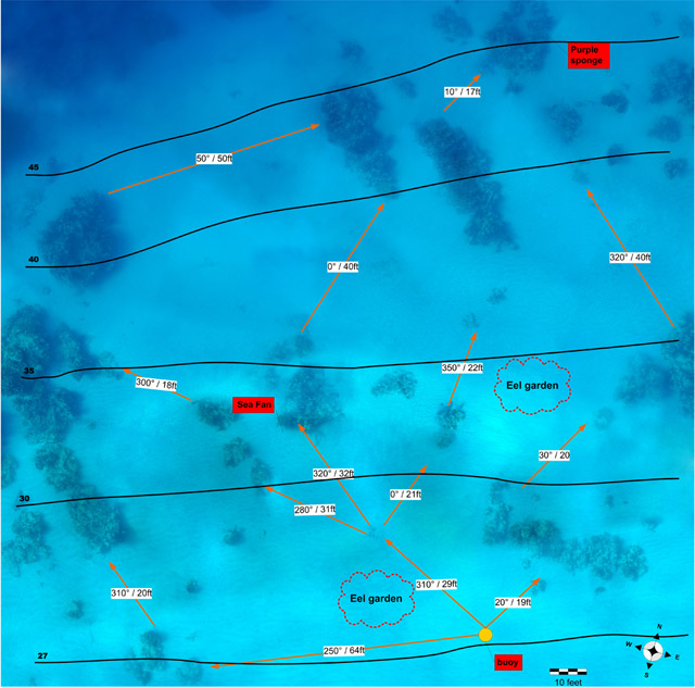
Hi all, for the divemaster course you have to make an underwater map. Since I know the area quite well, I figured id do something different instead of the normal map drawing.
I took hundreds of images, then stitched about 100 of them together in a large map. This was quite difficult because all the images have slightly different angles and distances. It took me days of working with Photoshop to select and combine all the images into matching strips. Then i put the strips together to form larger areas, until it all fit together. Then i put the extra information on it with Visio. It's not perfect, but still quite nice. Passed the course yesterday
For a larger image (1024) click here. Unfortunately i cant post the original (about 4500x4500) because im on a very slow modem link
Cor
Very nice Cor! And congrats on the divemaster!!
Ponsui
Excellent map - and kudos to you for putting some work into it! I hate seeing DM maps that look like they were thrown together in 5 minutes.....
Good Job!
That's excellent.
Very creative......what dive site (Location) is the map of?
This is at Cane Bay in St Croix. The photoshop stitching worked out quite well. What's cool is that in the original image you can zoom in quite far and see some reef detail and fish.
Wouldnt do it again though unless someone paid me for it What a job.
Cor
Spectacular! I am very impressed! It looks incredibly difficult. But it must be great to have a map to go back to...mayhaps I'll try mapping some of my favorite dive sites back home...
Good job! I dove in Cane Bay a few years ago, but not in this particular spot. I will save the map for my next trip, as I would love to see that eel garden. Is that dark area on the top left corner the start of the dropoff?
If you did a dive in Cane Bay, you must have been diving here This is right at the training buoy where everyone normally goes down. Unless you mean you didnt dive at Cane Bay, but only neighboring dive sites.
There are lots of eel gardens around. To the east of this map there are sand flats where there are eels as far as the eye can see. We often see stingrays and turtles there too.
The dark area in the top left isnt the best part of the map I ended up with no really useable photos in that area since it drops off quite quickly there and everything turned out pretty much dark. For the intended purpose i was happy enough. Didnt feel like going out and redoing that one spot. That is the top of the Wall. About 50 feet more to the north and it drops down sharply to about 3000 feet.
Cor
That is so cool. Very nice job.
Joe
Yes, technicaly I didn't dive at Cane Bay, I rented my tanks there and dove on a spot a few hundred meters (or yards, for the imperial unit guys) down the road, where the dropoff is closer to shore (less swiming!). This was back in 2001, when I spent 6 weeks in St Croix doing a fish survey at Buck Island with the National Park Service. I want to go back and do proper dives at Cane Bay (which I found to be fantastic), since at that time I spent most of my time in Buck Island. So far, the best two dropoff dives I did in the Caribbean were Cane Bay and Carrie Bow Cay (Belize).
You probably went to Northstar then. That's quite a nice site too. I actually prefer it to Cane Bay, but it's slightly more work so I dont bother
Cor
Very impressive! Looks like a useful skill for when DM's start doing pre-dive briefings using powerpoint!
But seriously, this could be a useful thing to have for a research project. However, you might have to re-do these on a regular basis (e.g., to look for change).
Tom
Great job Cor,
I've seen a lot of divemaster cadidate maps in the 5 years I lived on St Croix and this is definately a great way to aproach it. Did you shoot it all from the surface or from a pre-selected depth. It would be nice to see all the north shore sites on St Croix mapped in this manor and put together in book form. Can you imagine a continuous u/w map from Buck Island through Salt River, Cane Bay and finishing down at Davis Bay?
Again, Great Job
Doug Kaufman
PADI Course Director 31169
I did a total of 3 runs, but that was mainly because I hadnt done it before. I tried to stay about 30 feet above the bottom, so all images would have the same distance. But that turned out a be too much of a hassle. The second and third run I just stayed at the surface, or actually 2 feet or so below it, and took a lot less images. I fixed the distance problems in Photoshop. The distance problems werent so bad, whats worse is angles that arent exactly the same.
I can very well imagine a map going along the whole north shore, but it'd takes months, if not years of fulltime work
Cor
Very cool, What focal length did you use to take the pictures?
Now you need to redo your photoshopping but dont resize the immages. Then take your stitched 600MP image and print it out 30ft across. You can then charge touists $50 to look at your image. They will gladly pay because they will be able to see the reef better in your picture than the could in real life snorkeling, and this way they dont even have to get wet.






 I ended up with no really useable photos in that area since it drops off quite quickly there and everything turned out pretty much dark. For the intended purpose i was happy enough. Didnt feel like going out and redoing that one spot. That is the top of the Wall. About 50 feet more to the north and it drops down sharply to about 3000 feet.



